The Raddest ‘blog on the ‘net.

Friday, August 17, 2007

Boulder’s Murals

Mike,
Every week or so, I discover another mural in Boulder–usually on the outside of a wall, sometimes on the inside of a restaurant or a store. There’s a few more murals that I haven’t managed to photograph, but there are enough now on my camera disk to make an entertaining collection.

Enjoy the free-spirited artists of Boulder!

–rakkity

(P.S. An album of Glacier National Park’s high country is in the works, and will come to the blog before Aug 30, my “drop-dead” date.)

posted by rakkity at 6:20 am  

Friday, August 17, 2007

Boulder's Murals

Mike,
Every week or so, I discover another mural in Boulder–usually on the outside of a wall, sometimes on the inside of a restaurant or a store. There’s a few more murals that I haven’t managed to photograph, but there are enough now on my camera disk to make an entertaining collection.

Enjoy the free-spirited artists of Boulder!

–rakkity

(P.S. An album of Glacier National Park’s high country is in the works, and will come to the blog before Aug 30, my “drop-dead” date.)

posted by rakkity at 6:20 am  

Tuesday, July 31, 2007

A Walk In The Hills

craterlakeview.jpg

Hi Mike,

My old buddy Joe, a long-standing member of the Fogies Five (and an even longer-standing member of the “B.A.D.” club when we were CU grad students), and I went on a hike up to the alpine meadows of the Crater Lakes cirque, 30 miles west of Boulder. Along with us came Wayne, Joe’s postdoc. Wayne is from the Phoenix/Tucson inferno, and hasn’t had much of a chance to cruise the high country. The hike up to Crater Lakes exceeded all of our expectations. After 3 miles of steep hiking through the woods, we reached timberline, and found one of Colorado’s finest alpine meadows. We lolled around among the flowers, and would still be up there (I’m writing after dark), were it not that threatening thunderclouds and lightning drove us out and down the trail. We hiked on home wards through a refreshing hailstorm and found Boulder wrapped in clouds, teeming with rain. Wayne carried back a rapidly melting chunk of a snowfield from the cirque, so he can show it (re-frozen) to his Arizona family, many of whom have never (!) seen snow.

Another great day in the Rockies!

Photo Gallery

Ed

posted by rakkity at 8:49 pm  

Friday, July 13, 2007

Road Trip

sanfrancisco_pano.jpg

Hi Mike,

Beth & I are taking advantage of my current 2-week respite from doctors to visit the SF Bay area for 3 days. The pano is shot from the Space Science Lab atop Grizzly Peak on the UCB campus (where I’m working). I’m trying to get a good sunset picture from this great vantage point. Yesterday the weather was mostly cloudy, but today is as clear as a typical Colorado day, cerulean skies and all.

On Saturday, Beth and I will drive down the coast to Simi Valley, where we’ll visit my dad for a week. We’ll try to send more pics, perhaps of nice vineyards full of Pinot Noir grapes.

rakkity

posted by rakkity at 11:33 am  

Sunday, July 8, 2007

Pano From 75th St

Mike,

For me, the ideal Rocky Mountain panorama has to have (1) green swards (preferably with grazing buffalo) in the foreground, (2) crystal-clear air, (3) snow covered mountains, and (4) Ansel Adams clouds extending to the zenith. Unfortunately I’ve had to make compromises. Greening up doesn’t happen till May, the buffalo haven’t been around here for a while (though a huge buffalo sanctuary just opened up this year in Adams county to the south of us); the air isn’t so crystal-clear all the time; the mountains lose much of their snow in late May, and Ansel clouds don’t tower over the mountains until June.

So the best I could do was make a pano on May 25 when we had (1), (2), (3), and almost (4). But my tripod suffers from tiltitis, so I couldn’t get a frame on the left with a nice old barn, and the clouds moved fast enough to change noticeably between pictures. The clouds don’t tower as much then as they do now in July. (Boy do they tower!)

{Click on the link below to see the pano, and then stretch your browser window. It is huge which is why the script wouldn’t create a tidy thumbnail version.

green-longs.jpg }

But the good news is that I’ve found an even better vantage on Westview Ct, in a vacant lot (!!!) that has the best view in the neighborhood, and somehow hasn’t been developed. Maybe the developer is waiting for multi-dinero from some rich, somewhat reluctant, customer. I’d better move fast.

Perhaps this October there will be an early snowfall, and criteria 1,2, 3, & 4 will be met. So I hope to get another pano then, maybe with a better camera, and a solid tripod.

–rakkity

posted by michael at 9:31 pm  

Monday, July 2, 2007

Sister-City Mosaics

Mike,

I keep thinking I’ve seen most everything Boulder has to offer, but almost every time Beth & I go for a walk or a drive thru Boulder, I see something new.  This time I was walking by the City Hall, and ventured over to their new plaza, which just opened up in May. The city has placed 6 beautiful mosaics into the flagstone plaza.  I’ve attached some pictures. You’ll see some strange city names there–all 6 of the “sister” cities who have contributed to Boulder in various ways.  I’ve never been to any of them. (Should I be packing my bags?)

Enjoy.

rakkity

posted by rakkity at 11:39 am  

Thursday, June 28, 2007

A Hike In The Park

Hi Mike,

Today, an old friend, Steve Nerney, who moved out here to Boulder from the East late last year, came with me up to Rocky Mtn Nat’l Park for a hike. For our jaunt, I had selected Granite Gorge, a spectacular canyon ending in a Yosemite-like cirque at 10,200′, just below Long’s Peak. Ten years ago, I had hiked in the same area to do a climb of the monolith called Spearhead up there, and remembered the Gorge and the high cliffs very well. Steve has not yet acclimated completely to Boulder’s altitude, so he has to stop and catch his breath a lot on hikes. But he is utterly tireless, and he carries on a stimulating conversation where ever we go. During the hike he kept remarking on the outstanding beauty of the scenery, and I couldn’t but agree!

Here are some pics.

The last picture, taken at the YMCA next to the park, is where Steve’s wife is attending a meeting, and their son, Eddie, is climbing, rafting, and hiking to his heart’s content.

Ed/rakkity

posted by rakkity at 7:20 am  

Sunday, June 17, 2007

Crescent Moon Tonight

crescentmoon.jpg

Mike,

Yesterday evening we drove back from a trip to the Pike’s Peak area, and the sunset was so spectacular I nearly drove over the median strip several times trying to get a glimpse of it. If my loving wife hadn’t prevented me, i would have shot pictures out of the window while I was driving (like someone we all know and love, who will remain nameless). Anyway I was so energized by that sunset, I tried to get a good photo of a less spectacular post-sunset scene tonight from our front lawn. The clouds were not nearly so accommodating, but the crescent moon and Venus (below the moon at about 4 o’clock) hung out nicely for us over a maroon cloud deck.

Now that I know this camera can do this kind of work, I’ll try some more in future evenings.

Ed/rakkity

Details:

Dimensions: 1813 x 1406 (after cropping)

Device make: Nikon

Device model: E4200

Color space; RGB

Focal length: 23.4

Exposure time: 1

Support: convenient tree

posted by rakkity at 6:29 am  

Friday, June 15, 2007

Coming soon …

…to a nearby blog:


-o- Carved in Stone — In Colorado, stone is as cheap as dirt (maybe cheaper). Hence many signs are literally carved in stone.

-o- Boulder Murals — There aren’t any Grohes in Boulder, but the local artistes and graffites have created some nice outdoor art.

-o- Funny Business — It’s my impression that Boulder has an unusually large percentage of curiously named businesses.


–rakkity

posted by rakkity at 10:24 pm  

Thursday, June 7, 2007

Well Behaved Women Seldom Make History

Mike,

Before we came to Boulder last January, I was thinking that some aspects of the town would be much the same as when I lived here in the ’60s: political activism, marches, inflammatory posters, streaker parades, and above all, wonderfully diverse bumper stickers plastered on every car. Well, that’s only partially true. There are a diverse bunch of bumper stickers here, but I have seen bumper stickers on only about 1 car in 30. That’s much less than in Bowie, where it seemed like every other car has a Bush/Cheney or a Kerry/Edwards sticker. However, Bowie sported few really interesting/funny/scandalous ones.

So, since January, 2007, I’ve been peering at every bumper sticker that came within range. For 5 months, I looked in vain for a Bush/Cheney bumper sticker. To my happy surprise, None! Nada! Zip! So I tentatively concluded that, since Colorado is nominally a Red state (see footnote), with lots of conservative ranchers, the Bushies must avoid Boulder as a source of plague-bearing liberalism. Either that, or the city has posted automatic laser beams at every entrance to town, and the labels and/or cars with Bush/Cheney on them get vaporized as they drive in.

After viewing the rear ends of over 1000 cars, I started transcribing my scribbled notes into electronic media. Then, just before CU’s graduation day I happened to see a pickup truck near the campus, spotting a Bush/Cheney bumper sticker below its MONTANA plate. Somehow that truck managed to evade the laser beams. I don’t include on the list because I’m counting only Colorado cars.

Footnote:
Colorado has a Democratic governor, 4 of its 7 congressmen are Democrats, and the senators are split between the parties. Seems like it should be, nominally, a blue state.

–rakkity

posted by rakkity at 7:25 pm  

Monday, June 4, 2007

Canyon Chronicles, Part IV (Conclusion)

1617desertrat.JPG

FENCE CANYON CAMP

After several fierce struggles scrambling through walls of tamarisk while entering or leaving a ford of the Escalante, we were happy to reach the sanctuary of Fence Canyon. A family of 5 were enjoying the pleasures of the river bank. The 3 kids, 2 boys and a 11 or 12 year old girl were plastering each other with mud and water, while their parents relaxed on the bank. We sat down and chatted. They were both teachers from Missoula, Montana, escaping from the spring mud season (obviously there wasn’t enough of it back home for their kids). They had just hiked down from the rim, and at dusk they would hike back up Fence canyon to their car.

Inspiration struck me, and I mentioned how our Toyota Forerunner had been misplaced by our shuttle driver several miles up from the Fence Canyon trailhead. They both exclaimed that they’d be glad to help us out, drive our car back down to the trailhead. Chuck handed over the car keys and we arranged a plan B, in case they couldn’t find the car. In that case, they’d place our keys under the trail register. We talked some more about llamas, tamarisk and water, thanked them, said goodbye and left to find a camp. On the way I joked, “Any bets on whether we’ll find a note at the register saying, ‘So long suckers. Thanks for the Forerunner’.” Chuck didn’t laugh.

We found a little plateau above the river, between the cottonwoods and the local cliff. We dropped our packs, sat down on convenient rocks, and toasted each other with libations of Scotch and Irish whiskey. Close by was an ancient horse tie-up rack, and a cabin platform put there about a century ago by some early Mormon settler, no doubt. The cliff behind it showed what may have been the owner’s barely decipherable scratches. Reed pointed out some other scratches higher up–real Indian petroglyphs with drawings of deer and other animals. Who knows how old those were?

While we were sitting there, a chain of llamas came up to the horse rack and milled around. The owners of the packs the llamas were carrying milled around too, while the llama packer guy fiddled with the packs. Apparently they had been thinking of camping where we were. We sent daggers from our eyes, and they must have penetrated the packer’s brain, because after a few minutes he drove the llama up the canyon a way. The hikers followed docilely to their new camp site.We resumed our whiskey sipping, and watched the opposite canyon turn from brown red to crimson to black as the sun set.

NEON CANYON

The next morning, shortly after the crack of dawn (11 am), we discussed hiking to the nearby Neon Canyon. Hard-man Chuck decided he would rest his weary knee, and let his blister heal a bit that day, right there under the local Cottonwoods. Reed and I bent our heads over the tattered Xerox copy Chuck had made of his guide book to the area. Neon canyon appeared to have something called the Golden Cathedral at its upper end. A picture in the book showed a guy hanging on rappel from a hole in the overhanging cliff, his feet dangling above a little pool that reflected light into the cathedral-like stone. So Reed and I set out with a goal in mind that made our forays into the thickets of tamarisk easier to bear.

Once we got into the Neon side canyon, we were back into the shadows of closely spaced redwalls. Walking along we could see the high redwalls reflected in the little meandering stream and its random pools. At one of the wider parts of the canyon we spotted two charcoal-grey llamas nicely camouflaged behind stands of grey-green brush and cottonwood bark. We figured someone had left them to take care of themselves while they went hiking.

The canyon twisted and turned, and after climbing over boulders, and avoiding gardens of lush poison ivy, we entered the sanctum of the Golden Cathedral. The walls on either side joined, and formed an overhanging dome above us. A couple of big holes in the cavern’s ceiling passed sunbeams down into the pool below. No rappelers dangled there at that moment, but we caught a glimpse of a very narrow slot canyon beyond and above that might be passed by clambering down from the rim. (Later I found a website, that describes a tricky passage down to the cathedral

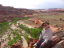
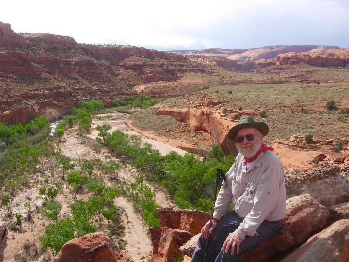
On the way back home, just before we left the Neon canyon, Reed noticed a trail that went up a series of bushy terraces and seemed to climb to the top of the mesa above us. We climbed up it and found an unparalleled vantage point. We could see up and down the Escalante for miles in either direction. Upstream there was Fence Canyon going beyond a bend on the opposite side of the river. Every meander was bordered at its extreme by a vertical cliff, and a wall of tamarisk on the opposite side. There did seem to be a direct route back to our camp avoiding two fords and much of the tamarisk via an open area cleared, presumably, by the great floods of 2005. Looking back in the direction of Golden Cathedral, we reckoned it would be possible to come down from the rim (and trailhead) to this mesa. That would make a day hike down to Neon a possibility.

We returned to camp and told Chuck what he had missed. We studied some Indian petroglyphs on the walls near our camp, and pondered their meaning. Was this a hunting camp used by the Anasazi hundreds of years ago? That night I took a couple of shots of dazzling Venus using my delayed timer and miniature tripod. The stars in the picture are real, but Venus is highly over-exposed, and looks like a big oval, about like the phase it was in at that time, but enlarged about 10 times.

FENCE CANYON TREK

Next day’s hike up Fence Canyon to the rim was tiring but uneventful. As we trekked upwards, I had my sights on a lower part of the rim that looked accessible, but the trail veered straight towards a very unlikely cliff. As we got higher, the ground became drier and dustier. But in the powderiest, dustiest soil, fields of pinkish-cream desert primroses proliferated. They must have sprouted up in the last couple of days after the rainstorm on our first night. During the final part of the ascent, the trail crossed bare rock with occasional cairns to show the way.In steeper places, there were footholds carved into the stone, by whom, or how long ago, we couldn’t tell. At the final rim a welcome sight appeared–Chuck’s car, which had been delivered safely by our Montana friends.

BARR TRAIL

We drove Colorado-ward via the Barr Canyon trail. This “trail” is a narrow paved road running through a spectacular canyon with high red walls, much like lower Harris, but civilized. Here and there are easily-reached side canyons to explore. One of them, unnamed, was only about 8-10 feet wide and hundreds of feet high. Along the way we passed a turkey fleeing the road–one of the squabblers like we had heard in some of our earlier camps.

As we left the Escalante region via Capitol Ridge and Arches NP, we peered backwards towards Escalante, and discussed our next trip to that rugged desert country. There are a near infinity of great canyons to hike through out there. We’ll be back!

Photo Gallery

–rakkity

posted by rakkity at 7:25 am  

Thursday, May 31, 2007

Bizarro Villes

Mike,

Shortly after moving from Bowie, MD to Boulder, CO, I started thinking about the differences between the two towns. Was there anything I really missed in Bowie that I’d like to go back for? No. Most of our Bowie friends have moved away, Or they already lived in other places, so there were very few people left in Bowie for us to go visit. And now we live in a place that friends and relatives go out of their way to visit. Why do they come here (aside from visiting us, that is)? Well, let me count the ways. I listed the differences between the two towns and found them so different, that they are like Bizarro worlds. Maybe not so extremely different as the worlds in DC Comic Books, but really, really different. I could list even more differences than I have in the link below, but I want to spend more time actually enjoying the differences!

Bizarro Villes

–rakkity

posted by rakkity at 5:18 pm  
« Previous PageNext Page »

Powered by WordPress