Mike,
It’s been quite a while since I climbed a “real” mountain (i.e. one over 13,000 ft high) and I wanted to know if I could still do it in my late middle age. So I looked up at the Indian Peaks from 75th St, and thought about which one I hadn’t climbed. Navajo! It’s the one that looks like an inverted ice cream cone.
That pointy one right in the middle.
A call to hard-man Chuck found me a partner. When “legs” Joe heard about the hike, he wanted into it too. That was fine with both of us. Chuck recommended a 5:30 am start from Boulder. I blinked, but didn’t gulp. He said, ‘We’ve got to get on top of the mountain before noon to avoid the thunderstorms.” Thinking back the last few weeks, I recalled the plentitude of afternoon thunderstorms right here in Boulder, and agreed whole-heartedly. I had no desire to be dodging thunderbolts up above timberline.
Two mornings later at 5:30 am, Chuck and I were waiting in his living room for Joe. At about 5:45, about the time we expected him to show up (according to the Joe clock), Joe rolled up in his car outside. He headed straight for Chuck’s basement, where he stores his climbing stuff. At 6:05 we were headed down the street in Joe’s car, when he remarked casually, “We have to make one little stop.” Chuck & I looked at each other anxiously. Joe was famous for being late, but this was a new one. “I forget if I left my garage door open or not. I’ve got to check.” Our eyes rolled, but we agreed on this further delay. Finally we got out of town, having confirmed that Joe had actually shut his garage door, and we were on our way to the Indian Peaks Wilderness.
Brainard Lake to Timberline
The sun was just rising over the plains behind us as we started hiking the Isabel Lake trail from Brainard Lake. Striding easily along the forest trail, we passed Long Lake, then Isabel Lake, and then a small tarn surrounded by alpine meadows. The forest had now become scattered clumps oftwisted and beaten firs bordering fields of tall grass and willows, all watered by a gurgling creek.An obvious cirque, drained by waterfalls, stood a couple hundred feet above us. We followed the vestiges of an old trail to Isabel Glacier. The path twisted circuitously upwards around the waterfalls through marmot and pika country into the boulder field of the cirque. The trees and the last wildflowers fell further below us.
At about 10:00, 5 miles above Brainard Lake, we entered the arctic zone where only lichens and spiders wreak out a precarious existence on the rocks. And above us there hung Navajo Peak, a tough customer, it seemed to me.
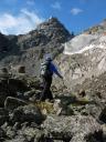
Airplane Gully
Sometime in the 1950s a small passenger airplane tried to cross the continental divide just south ofNavajo Peak. Due to clouds and a faulty altimeter, they hit the gully just a few 10s of feet below the pass. Pieces of the plane are scattered over the gully from the bottom of the cirque right up to near the 13,000 foot level, less than a hundred feet from safe passage. This is the least pleasant part of the climb. Not only are all these aluminum reminders of death and destruction everywhere you look, but the gully boulders are unstable and often roll beneath your feet. You are at risk of tripping, or jamming your foot in a hole, or having a big rock roll over your feet, and anyone below you is likely to get hit by a rolling, bounding rock. So we wore our climbing/bicycle helmets and climbed carefully.
Final Pitches
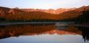
By the time we reached the top of the gully at Navajo Pass it was 11:15, and the final ascent lay just above us. There were wonderful views of the Continental Divide to the north and the south. Arapahoe Mountain, its dwindling glacier, and a few of its once major snowfields were now visible to the south. Longs Peak lay off to the north, bordered by its lesser satellites in Rocky Mountain National Park. The western mountains of Colorado lay specked with light and shadows cast by the overlying, fast-changing clouds. It was a worthy spot to rest.
Joe was tuckered out from fighting the gully, and decided to stay there at the pass and wait for us, if Chuck & I wanted to continue. He’s no “peak-bagger”, but I am, and so is Chuck. I stared up at the final 500 feet of climbing. It looked like a trail led up to the rim rock, below the top, but how do we get around that? Chuck was ready to go on. He had climbed this peak 5 or 6 times by 3 or 4 different routes, and he knew the way. He told Joe it would take about half an hour to reach the top (he was right), and probably less to descend to Joe. The anvil clouds were gathering in the west, and in the very far distance to the north, there were signs of lightning. So without delay we headed up.
There were no loose rocks on the ascent, and the trail was much easier than Airplane Gully. Still, both Chuck and I had to breathe deeply, and take in as much of the thin air as we could. The high rim rock that wraps around the summit grew closer as we climbed, and Chuck pointed out a huge crack in the rim. “That’s a chimney route that’s fun to climb.” At my questioning look, he said, “But we’re going to go an easier way.” Sure enough, we found a passage traversing the rim to the left and winding up onto a narrow ridge. Chuck tossed down his trekking pole, “We won’t need these now.” He climbed up onto a house-sized boulder, and led us on an airy, but simple, rock climb that led to the summit. The drop-offs to the north were insane. That was the glacier route, climbable only with crampons and ice-axes in late spring, when the gullies were choked with snow. A few more yards of scambling on lichen-covered boulders, and we were at the obvious compact summit.
Down in all directions!
Descent to the plains
Descending Airplane Gully took about twice as long as the ascent. But when we reached the flat boulder field below it, we breathed a sigh of relief. Only horizontal boulder-hopping now.
A short way onward, Chuck noticed a ptarmigan. It was initially invisible, but then it twitched and became visible. As we walked toward it, the bird walked slowly away. He never flew, but watched us carefully, confident in his camoflage. He was pretty sure we couldn’t see him. So there was, indeed, more life than spiders and licens in those boulders!
Slowly, slowly, slowly, we walked back into the meadows below the cirque, into the wildflower zone, past the lakes, through the woods to the car, to civilization and beer!
–rakkity
8/27/07
I have one more (short) thing to send you this week– “Cantering through the gayfeathers with Katie”